


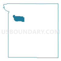
Voting District 12, Ottawa County, Oklahoma
About
Outline

Summary
| Unique Area Identifier | 654923 |
| Name | Voting District 12 |
| County | Ottawa County |
| State | Oklahoma |
| Area (square miles) | 8.96 |
| Land Area (square miles) | 8.88 |
| Water Area (square miles) | 0.08 |
| % of Land Area | 99.14 |
| % of Water Area | 0.86 |
| Latitude of the Internal Point | 36.90871410 |
| Longtitude of the Internal Point | -94.93613230 |
Maps


Graphs
Select a template below for downloading or customizing gragh for Voting District 12, Ottawa County, Oklahoma


Neighbors
Neighoring Voting District (by Name) Neighboring Voting District on the Map
- Voting District 11, Ottawa County, OK
- Voting District 13, Ottawa County, OK
- Voting District 2, Ottawa County, OK
- Voting District 3, Ottawa County, OK
- Voting District 9, Ottawa County, OK
Top 10 Neighboring County Subdivision (by Population) Neighboring County Subdivision on the Map
Top 10 Neighboring Place (by Population) Neighboring Place on the Map
Top 10 Neighboring Unified School District (by Population) Neighboring Unified School District on the Map
- Miami Public Schools, OK (15,278)
- Commerce Public Schools, OK (4,088)
- Welch Public Schools, OK (1,882)
Top 10 Neighboring State Legislative District Lower Chamber (by Population) Neighboring State Legislative District Lower Chamber on the Map
Top 10 Neighboring State Legislative District Upper Chamber (by Population) Neighboring State Legislative District Upper Chamber on the Map
Top 10 Neighboring 111th Congressional District (by Population) Neighboring 111th Congressional District on the Map
Top 10 Neighboring Census Tract (by Population) Neighboring Census Tract on the Map
- Census Tract 5747, Ottawa County, OK (4,573)
- Census Tract 5741, Ottawa County, OK (4,150)
- Census Tract 5742, Ottawa County, OK (3,132)
- Census Tract 5744, Ottawa County, OK (2,833)
- Census Tract 5743, Ottawa County, OK (2,710)